Sea Monsters and Maps

Sea Monstors  on Medieval and Renaissance Maps

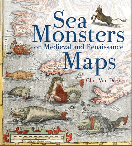
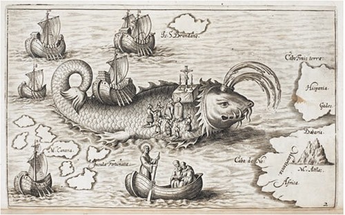
This great picture [St. Brendan’s ship on the back of a whale, and his men praying, in Honorius Philoponus, Nova typis transacta navigatio (Linz: s.n., 1621), p. 12 (British Library, G.7237)] comes from Sea Monstors on Medieval and Renaissance Maps by Chet Van Duzer and published by the British Library. They say

Whether swimming vigorously, gamboling amid the waves, attacking ships, or simply displaying themselves for our appreciation, the sea monsters that appear on medieval and Renaissance maps are fascinating and visually engaging

Below is the cover picturing more great sea monster drawings. These sample pages (PDF) have more pictures, maps and excerpts from the book.

sea_monsters_cover.jpg

Atlas for the Blind

The map below — from the “Atlas of the United States Printed for the Use of the Blind” — was published in 1837 for children at the New England Institute for the Education of the Blind in Boston. Braille was invented in 1825, but this atlas uses embossed letters for place names as well as longitude and latitude. The map is from the David Rumsey Map Collection — they have over 32,000 map and map-related items online. You can see all the pages they have from the Atlas here.

First map (of Maine) in an 1837 Atlas of the United States for the Use of the Blind.

Maps: Walking with a Toddler

After finding Bo Press Miniatures on Etsy the other day, I’ve been looking at other book artists who sell there. The map below is from Brian Kring and his Emporium of Tiny Literature, Cards and Other Things Paper. The letterpress printed map below details the neighborhood walk he takes with his 3 year old son. The outline is printed letterpress and then hand colored. Brian has other artist’s books, moveable cards and paper sculptures here. He’s also got a website with more of his work.

Brian Kring’s map

Flower Maps

Over the past several weeks I’ve continued to play with a variation on the Turkish Map Fold. I thought an image that spanned the entire book might work well and revisited the pictures I took in Mt. Rainier National Park some years ago. The photos and structure fit a haiku I wrote last year, and I especially like the effect of printing photos on the reverse, giving the viewer something to look at on the underside of the folds. I was so pleased with the results that I’ve made an edition of 15. It’s called Flower Maps and you can see many more photos here.

How To: More on the Turkish Map Fold

map-fold-5.jpgAfter making my first prompt challenge book using the turkish map fold, I kept thinking about the fold and how I might use it in other books. I tried making a book with multiple folded pages, glued together, but the result was unsatisfying. The folds from the last couple of steps seemed to be in the way, making the pages difficult to open. So I tried stopping at the 5th step, where the page or sheet looks like the figure on the left.
I glued a few of these pages together but didn’t much like the results of that either. After more fiddling around, I tried gluing 2 folds together, turning the result 90 degrees, and gluing them to one half of a piece of card stock (with the point at the outer edge). The card stock is the same size as the original sheet of paper. When I glued another pair of folds to the other side of the card stock, I had a structure that opened quite wonderfully! And a place in the center for some text. (The 2 rectangles at either end make a cover that opens from the center.)

Opening the book reminded me of a flower blooming. Here’s a model I made, with one of my favorite Emily Dickinson poems, Bee! I am expecting you!
map-fold-1.jpg
map-fold-2.jpg
map-fold-3.jpg